|
|
|
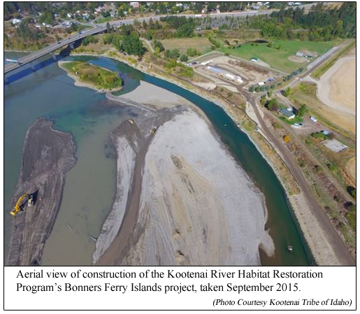
Still wondering about the heavy equipment in the
Kootenai River? All your questions answered
here. |
|
October 14, 2015 |
Anyone who drives across the Kootenai Bridge in
Bonners Ferry can see the curious sight:
excavation equipment, heavy trucks, dozers, and
other heavy equipment operating right in the
river. The gradual emergence of two large
islands in the river across from the Kootenai
River Inn, along with work being done on the
river bank.
 Everyone knows all this has something to do with
the Kootenai Tribe's work to restore the
population of white sturgeon to the river. But
what exactly is going on? What is all the
dredging? What is the purpose behind all this
engineering of the river? Everyone knows all this has something to do with
the Kootenai Tribe's work to restore the
population of white sturgeon to the river. But
what exactly is going on? What is all the
dredging? What is the purpose behind all this
engineering of the river?
As far as what is going on with all the work
being done just above the Kootenai Bridge, we
have all the answers on that. But that part
comes up a little later in the story.
First, you have to picture in your mind a time,
not really that long ago, when giant sturgeon
roamed the depths of the Kootenai River.
Abundant in number, these fish provided a
cultural subsistence fishery for generations of
the Kootenai Tribe, and later a social and
economic fishery for others who made their homes
in the area we know today as Boundary County.
Similarly, burbot, a type of freshwater cod, was
found in dense numbers in the river. They were
once so abundant that burbot were often caught
in large quantities. Catching burbot was often
done in the wintertime, when one could cut a
hole in the ice and put up a baited setline.
Very often the burbot would be caught in the
west side tributaries of the Kootenai, such as
Smith Creek or Boundary Creek. Cutting a hole in
the ice there would often reveal many burbot
simply laying under the ice. The two to three
foot long cod were often speared, and brought
home loaded up in sleighs, or filled into
gunnysacks.
Though the populations of these fish remained
resilient in the face of heavy fishing for what
might be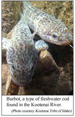 considered a remarkably long period of
time, eventually, in the later half of the
previous century, the toll that intense and
growing pressures of over harvesting began to
exact became more apparent as the numbers of
these fish dramatically fell. considered a remarkably long period of
time, eventually, in the later half of the
previous century, the toll that intense and
growing pressures of over harvesting began to
exact became more apparent as the numbers of
these fish dramatically fell.
But it was more than fishing that clobbered the
Kootenai River's sturgeon and burbot. The river
itself changed. Previously the Kootenai River
had provided an environment in which the fish
thrived. Gravel-laden river bottoms in areas
where the sturgeon spawned provided a safe area
for their eggs to fall, where they would stick
to and be safely hidden amongst the rocks. Fish
could hide or rest in deep pools scattered along
the river, or in shaded spots along irregularly
contoured riverbanks studded with logs or rocks.
Vegetation grew along the banks that provided
habitat and nourishment for land animals and
insects that factored into the food chain for
the fish. Floodplains, areas where the river
overflowed its banks during high water seasons,
provided important nutrients for the river
system and habitat for some native fish, birds,
and other animals.
Over the years, that version of the Kootenai
River gradually changed. Dikes were built along
the river banks to help control flooding. The
dikes altered the natural vegetation along the
river, and cut off the river's connection with
its natural floodplains, many of which were
converted to agricultural cultivation. In 1975,
the newly-constructed Libby Dam was dedicated.
The construction and operation of the dam
altered the naturally occurring flows of the
river, and had other effects including changes
in temperature of the river water, and the way
sediment was deposited along the river.
These changes dramatically improved the
devastating effects of flooding along the river,
helped to make farming the rich soil of the
Kootenai Valley more practical, and together
made a huge contribution to the economic
viability, job creation, and progress of the
residents of Boundary County.
But those changes to the Kootenai River altered
the environment that helped many of the native
fish of the river to flourish.
Gradually their numbers fell. The time came when
you would crack open the ice at Smith Creek, and
find no burbot there to gather into gunny sacks.
The white sturgeon population of the Kootenai
River shrank to the point that in 1994, they
were listed as endangered under the Endangered
Species Act. The burbot of the Kootenai River
was proposed for Endangered Species Act listing
in 2000, but were not listed as they did not
meet the Act's "Distinct Population Segment"
criteria. Still, as the burbot population
dwindled, estimated at one point to number an
estimated 50 fish, burbot were considered to be
functionally extinct in the Kootenai River.
The Kootenai Tribe began their hatchery program
in 1989, with efforts initially directed toward
conservation of the Kootenai River's white
sturgeon. In coordination with the University of
Idaho the Tribe also began exploration of ways
to raise burbot in a hatchery, something that
had never been done before.
(Story continues below photo).
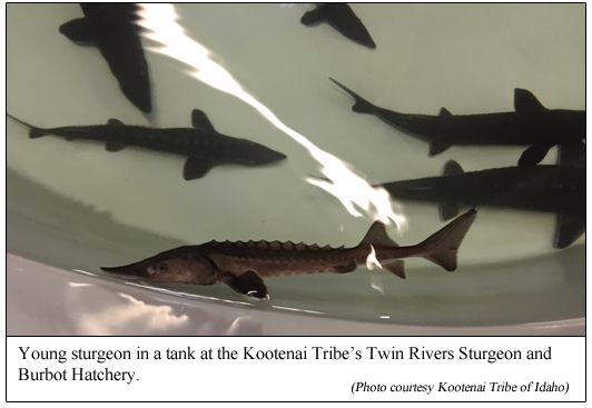
The efforts to grow and restock sturgeon and
burbot back into the Kootenai River were
remarkably successful, and over the years the
tribe and its partners have released thousands
of sturgeon and burbot into the Kootenai River
system.
As the aquaculture program grew, it eventually
became apparent the original facilities for the
program, located near the Kootenai Tribal
Reservation, were becoming too small for the
growing and increasingly successful program.
A new hatchery was planned for the Twin Rivers
area, at the confluence of the Moyie and the
Kootenai Rivers. After two years of
construction, the new, modern, state-of-the-art
Twin Rivers Sturgeon and Burbot Hatchery was
opened and dedicated last October.
Even though the program to raise and
re-introduce the fish into the Kootenai River
found great success, a significant issue still
remained: The river itself. This was not the
Kootenai River of 100 years ago, unencumbered by
the Libby Dam, and unchecked by dikes along its
banks—a river in which the sturgeon and burbot
had once flourished.
"Although many factors have altered river
habitat for sturgeon, burbot and other native
fish," said Susan Ireland, Fish and Wildlife
Department Director for the Kootenai Tribe of
Idaho. "To our knowledge, construction and
operation of Libby Dam and the elimination of
the river's connection to its floodplain have
had the most decisive and profound impacts."
"The construction of dikes to create farmable
lands and to protect communities from flooding,
cut the river off from and eliminated huge areas
of historical floodplains," she explained. "The
floodplains were really important because they
provided nutrients that are essential to a
healthy food web. The floodplains also provided
habitats used by some native fish as well as
other species such as birds. Floodplains provide
the grocery store for the fish in the river.
"Construction of Libby Dam trapped sediments
from the upper watershed behind the dam. Those
sediments were also rich in important nutrients
that fed the downstream river. In addition, the
river would transport the sediments downstream
during spring flows and deposit them on bars in
the rivers, along the banks and on the
floodplains, thus creating and maintaining
habitat for native vegetation such as
cottonwoods and willows that further contribute
to the food web, create shadowy hiding places
along the banks of the river, and stabilize the
river banks.
"Historical and ongoing operations of Libby Dam,
although important for flood control and power
production, have significantly altered the way
the river functions and the quantity and quality
of fish and plant habitats. Spring flows have
significantly decreased, altering the capacity
of the river to transport sediment, gravel and
rock. Winter flows have increased, and winter
power peaking further exacerbates the situation
by causing increased erosion of the riverbanks
and scouring off young cottonwoods and other
native plants that are trying to take hold.
Seasonal river temperatures are also altered by
dam operations."
These newly-raised hatchery fish, carrying the
hopes of jump-starting the resurgence of their
populations in the Kootenai River, were being
returned to a river with the same issues that
had contributed to the decline of the original
populations of sturgeon and burbot: loss of
natural seasonal flows, altered seasonal water
temperatures, changes in silt deposition, loss
of natural flood plains, severe erosion of the
riverbanks leading to loss of native riverbank
vegetation and loss of irregularities--nooks and
crannies--in the riverbank which provided pools,
shaded areas, and eddies where fish could hide,
rest, or feed.
It was apparent that for sturgeon and burbot to
be sucessfully restored into the Kootenai,
important river features necessary for thriving
populations of these fish needed also to be
restored.
It was also apparent that the Libby Dam and
flood control measures, including the dikes,
were necessary and important for the communities
and people who lived along the river. Could
there be a way to restore river features vital
to the success of the sturgeon and burbot
programs, and still work within the realities of
the Kootenai River today, and the communities
alongside the river?
“Finding a way to help the river work the way it
is supposed to, without sacrificing flood
control, and in a way that respects local land
uses and community values, is what the Kootenai
River Habitat Restoration Program is all about,”
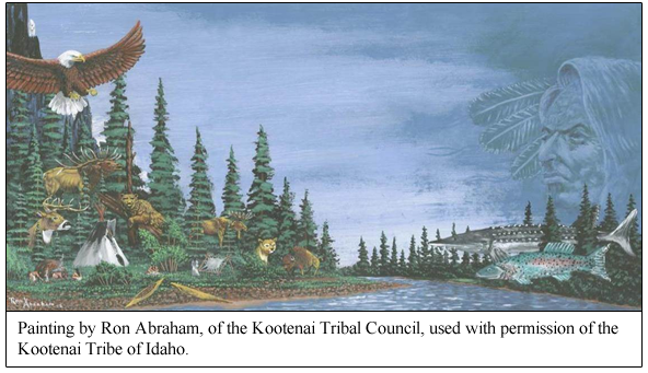
said Ron Abraham, of the Kootenai Tribal
Council. “The Kootenai River is the backbone of
our community, and we are all stewards of this
unique piece of our cultural and natural
heritage.”
"The challenge was to find ways to create those
favorable habitat conditions while working
within the existing constraints," according to
Ms. Ireland. "This means, designing projects
that will work and be sustainable within a range
of different river flows. Making sure that the
projects don’t increase flood risk to Bonners
Ferry, or require additional flows that might
increase flood risk."
"And since the majority of land along the
Kootenai River is privately owned," added Mr.
Abraham, "it also means working with willing
private landowners to implement individual
projects without doing harm to existing
agricultural or other land uses."
In assessing how the problems would be addressed
and programs designed and implemented, the Tribe
established the Kootenai River Habitat
Restoration Program, and engaged a multitude of
stakeholders, put together multiple teams of
knowledgeable scientists, and sought public
input. Illustrating the breadth of involvement
in the program, representatives from the
following entities have partnered with the
Kootenai Tribe of Idaho in participating in
advisory teams or reviewing the habitat
restoration program:
• Bonneville Power Administration
• Idaho Department of Fish and Game
• U.S. Army Corps of Engineers
• U.S. Fish and Wildlife Service
• U.S. Geological Survey
• Montana Fish Wildlife and Parks
• Confederated Kootenai and Salish Tribes
• British Columbia Ministry of Forests Land
Natural Resource Operations
• University of Idaho
• Bureau of Land Management
• Idaho Governor’s Office of Species
Conservation
• Natural Resource Conservation Service
• Idaho Department of Environmental Quality
• Idaho Department of Lands
• Idaho Department of Water Resources
• Northwest Power and Conservation Council
• University of Lethbridge in Alberta
• University of California at Davis
• Bonners Ferry and Boundary County local
governments
• Kootenai Valley Resource Initiative
In addition to these entities, private
landowners and technical consultants including
biologists, experts in groundwater and sediment
transport, hydrology and engineering,
geomorphology, river design, engineering,
sediment transport and hydraulics, and modeling
were also actively involved.
The charge was to develop a program that would
best enhance the overall biologic system of the
Kootenai River, identify and implement projects
that would promote a thriving river ecosystem,
and do so within the constraints of the river
and community needs today.
"The Tribe’s overall approach to fish and
wildlife and their habitats is fundamentally an
ecosystem-based approach," said Ms. Ireland. By
that we mean that the Tribe’s individual
programs and projects at their core take into
account the whole community of living creatures
and the ways that they interact with other
non-living components of the environment such as
the water, air, soil.
"In terms of the Kootenai River Habitat
Restoration Program, this means that we’re not
just focusing on trying to restore one
life-stage of one species of fish. Instead,
we’re working to restore physical conditions
that allow the river to act like a river, and
allow the interconnected communities of plants
and animals to fulfill their diverse roles. That
is why the Kootenai River Habitat Restoration
Program in combination with other projects, such
as the nutrient restoration implemented by the
Tribe and the Idaho Department of Fish and Game,
is trying to restore conditions that will
support a range of self-sustaining native fish,
a healthy food web, and native plants. Since
humans are also part of the ecosystem, all of
this must also take into account the values and
priorities of local and regional communities."
Investing time and significant resources into
assessing what needed to be done and what could
be done to restore some of the desirable
physical conditions of the river, the Tribe and
its cooperating partners identified several
needs that could be addressed, and strategic
locations along the river where interventions
could best be employed.
Important river features that were needed, or
other interventions that looked to be helpful as
determined by the Tribe and its partners and
consultants, included, for example:
Floodplain
surfaces. "This is a key part of
the Tribe’s restoration approach because
floodplains support plant growth, and plants
support the food web, which in turn supports all
life in the river," said Tom Parker, a plant
ecologist who is part of the program's design
team.
"When Libby Dam began operations," he
continued, "Kootenai River flows were reduced so
much that the river no longer flooded its
historical floodplain often enough to sustain
many of the native riparian plants [plants
occurring naturally along the riverbank]."
The plan is to create new floodplain surfaces
along the course of the river, and establishing
these surfaces at an elevation that will be
watered only part of the year.
"By establishing new floodplains at a lower
elevation, we will be able to allow native
vegetation to develop at an elevation that can
be sustained by the river’s current dam operated
flows. This will also help restore some of the
vital floodplain functions that were lost when
the river was disconnected from the floodplain
by dikes," Mr. Parker said.
"Removal of current river dikes is not planned
in any of the Tribe's projects," added Ms.
Ireland. "All projects are also planned so that
they will not increase flood risk to the
community."
Deep pools.
These pools have been found to provide habitat
where sturgeon can "stage" (which is to get
ready) for spawning, and a place for these and
other fish species to feed and rest.
Sizing the
river channel. The old river
channel was created by river flows that were
much higher than those seen today with operation
of the Libby Dam. To help adjust the river
channel to today's dam-managed flows, the
program is trying to construct a more pronounced
river channel, by excavating pools and adding
structures or islands that constrict flows.
Address
erosion of the riverbank, and enhance "riverbank
complexity." The lack of
opportunities for the river to “let off steam”
at higher flows by flowing into the historical
floodplain, along with winter power
 operations
that raise and lower the river elevation
quickly, have helped create steep banks with
severe erosion in some areas. The lack of plants
and tree roots that help stabilize the river
banks have made them more prone to erosion. In
places where erosion is particularly severe,
with resulting sediment falling into the river
and threatening spawning areas, banks are
regraded to more sustainable angles. These
regraded banks are stabilized in the short run
with logs and brush that are partially buried
into the banks to slow the water, allowing
newly-planted vegetation to take root and become
established. In the long run, the newly
planted-vegetation should stabilize the
riverbanks as it matures, slow the water near
the banks and prevent erosion, and in general
provide more "complex" banks and better habitat
for fish and other animals. operations
that raise and lower the river elevation
quickly, have helped create steep banks with
severe erosion in some areas. The lack of plants
and tree roots that help stabilize the river
banks have made them more prone to erosion. In
places where erosion is particularly severe,
with resulting sediment falling into the river
and threatening spawning areas, banks are
regraded to more sustainable angles. These
regraded banks are stabilized in the short run
with logs and brush that are partially buried
into the banks to slow the water, allowing
newly-planted vegetation to take root and become
established. In the long run, the newly
planted-vegetation should stabilize the
riverbanks as it matures, slow the water near
the banks and prevent erosion, and in general
provide more "complex" banks and better habitat
for fish and other animals.
Plans were also made to provide structures
extending from the bank into the river
("pool-forming structures") with the intention
of further protecting the riverbanks, creating
eddies that many fish use, and to help direct
river flow. It was hoped that these structures
would slow down water along the bank to help
create more complex aquatic habitat.
Placement of
instream structures. This
includes placing rock or gravel onto the
riverbed, or placing structures directly into
the river to help form pools within the river or
to create other desirable hydraulic effects.
Side
channels. Reconnecting
long-blocked natural river side channels, or
constructing new side channels where needed, in
hopes of providing habitat for fish, reducing
sediment in the river overall, and help
reconnect floodplains to the river where
possible.
These are a few examples; other methods,
techniques, and river interventions are also
available to enhance the river's ecosystem.
The over-arching idea of all this, according to
Ms. Ireland, "is to restore more natural
in-river conditions to help the river heal
itself within the constraints of Libby Dam
operations for power and flood control, and
while respecting existing land uses.”
Along with identifying processes to enhance the
river environment for fish and other species,
the planners identified also specific parts of
the river where interventions seemed to be most
needed.
Once all the plans were set, goals identified,
and logistics worked out, actual work on the
overall program began in the summer of 2011.
From 2011 through 2014 there were seven projects
completed under the Kootenai River Habitat
Restoration Program. This included two projects
in 2011, two in 2012, two in 2013 and one in
2014. The six projects completed from 2011
through 2013 were all in the portion of the
river known as the Braided Reach, the area
immediately around Bonners Ferry and extending
upstream as far as the Twin Rivers area where
the Moyie River joins the Kootenai.
Those projects involved restoration of eroded
riverbanks and measures to prevent significant
future erosion, restoration of floodplains,
restoration of side channel habitat, excavation
of pools, construction of pool-forming
structures, and planting of riverbank vegetation
The 2014 project took place in the area of the
river known as the "Meander Reaches," which is
the slow, winding, meandering length of the
river that extends downstream from Bonners Ferry
to the Canadian border. In this project, rocky
material was placed on the riverbed in locations
near Shorty's Island and near Myrtle Creek—areas
where sturgeon are known to spawn, but seem to
have diminished survival rates due to
less-than-optimal sand and clay river bottoms.
In ideal conditions, it appears that sturgeon
eggs released by female fish, being very sticky,
adhere to rock or gravel on the river bottom,
where the eggs and the hatched larvae can hide
and be protected. It is hoped that adding rock
and gravel to these areas where sturgeon are
known to spawn will improve chances for survival
of these young fish.
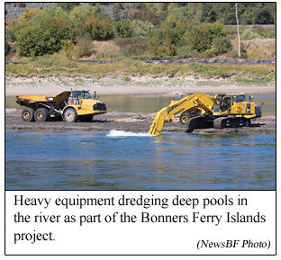
And that brings us to 2015, and what is going on
right now in the Kootenai River just upstream
from the Kootenai Bridge in downtown Bonners
Ferry. That work is known as the Bonners Ferry
Islands project.
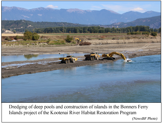
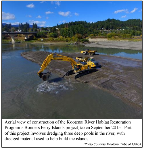
The Bonners Ferry Islands project, which we get
to witness every day, involves excavation of
three deep pools in the river, which is what we
see the large excavators working on in the
river. These deep pools will provide habitat for
spawning staging for Kootenai sturgeon, along
with deep areas where burbot and other native
fish can feed and rest.
These deep pools are part of a chain of pools
being created throughout the Braided Reach area
of the river.
(Story continues below photo).
Material dredged from the excavated pools is
being used to construct the Bonners Ferry
Islands, which will provide floodplain surfaces
and will be partially vegetated, providing
floodplain habitat that should contribute
important nutrients to the food web in that part
of the river.
These islands also affect size of the river
channel in that area, creating a more pronounced
channel to better match the lower scale of flows
seen under Libby Dam operations, and hopefully
improving the ability of the river to transport
sediment.
(Story continues below photo).
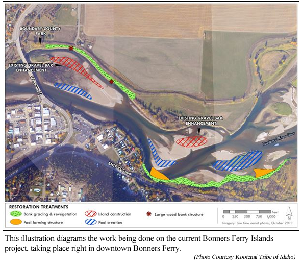
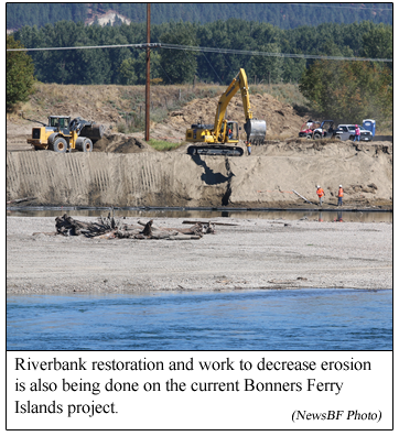
The Bonners Ferry Islands project also involves
construction of four structures that will extend
out from the riverbank into the river channel to
help protect the riverbanks and help form areas
of eddies. This project also includes work to
grade and improve eroded river banks and
revegetate the area.
Construction of the Bonners Ferry Islands
project will continue into November, then will
be put on hold until July of next year. It is
anticipated that the overall Bonners Ferry
Islands project will be completed by November of
next year.
This project is being done just upstream from
areas where sturgeon are known to spawn.
And that is what is going on with all the heavy
equipment we see today in the river, and all the
dredging going on, and why all that work is
being done.
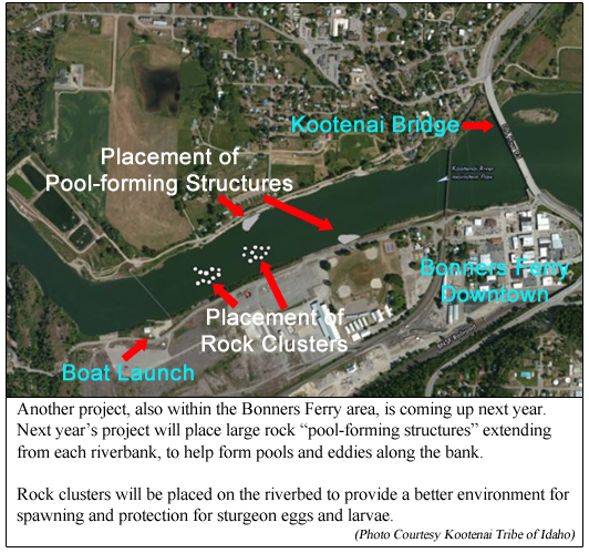
The Kootenai Tribe plans are to begin
construction of another project next year, just
downstream of the Kootenai Bridge. In that
upcoming project, two rock spurs will be added
along the riverbanks to create more complex
riverbank in-water habitat, and clusters of
rocky material will be placed on the riverbed in
efforts to enhance survival of larval and other
young sturgeon. That work will also be seen from
Bonners Ferry, this time downstream from the
Kootenai Bridge.
(Story continues below photo).
Additional projects downstream and upstream from
Bonners Ferry are currently in the concept and
planning stages. Construction of those projects
is tentatively planned to begin in 2017 and
2018.
A few questions naturally arise in considering
this comprehensive plan to restore habitat in
the Kootenai River. Likely the first question of
all is,
1. How is this all being paid for?
Under the Northwest Power Act passed by Congress
in 1984, the Bonneville Power Administration is
required to mitigate losses to fish and wildlife
affected by the federal hydropower system in the
Columbia River Basin (of which the Kootenai
River is a part). Around $250 million is made
available each year for this program. That $250
million comes from fees built into regional
power rates. “This money is distributed
throughout the entire Columbia River Basin
through a competitive process managed by the
Northwest Power and Conservation Council, which
incorporates rigorous science and policy reviews
of all proposals,” observed Ms. Ireland.
The Kootenai Tribe competed for and won funding
for the Kootenai River Habitat Restoration
Program through this process. “We’re really
excited about the opportunity to bring these
resources back to the Bonners Ferry community,”
said Ms. Ireland. “It’s a question of fairness.
Libby Dam plays a really important role helping
to protect the Bonners Ferry area from flood
risk. However, as part of the federal Columbia
River power system, a lot of the power and
revenue benefits of the dam flow downstream to
other communities. Additionally, the vast
majority of the mitigation funding is spent
downstream,” she said.
“Being able to bring some of those resources
back home to invest them on the ground in
Bonners Ferry is really important. We are glad
that it can provide economic benefit to the
community as well as benefit to the fish.” Ms.
Ireland concluded.
Hence, the primary funding for the Kootenai
River Habitat Restoration Program is from this
mitigation funding of the Bonneville Power
Administration through the Northwest Power and
Conservation Council’s Fish and Wildlife
Program.
In 2011, the Kootenai Tribe was awarded a grant
of $250,000 from the Idaho Department of
Environmental Quality. In 2013, BNSF Railway
contributed $160,000 to support the Middle
Meander project. To date, those grants and the
BPA mitigation money are the only direct sources
of funding for the program.
What has it cost? From 2011 through 2015, the
costs of individual Kootenai River Habitat
Restoration Program projects have varied based
on the amount and type of work required.
Averaging about two projects per year since
2011, construction costs for the overall program
have ranged from approximately $1.7 million to
$4.5 million per year.
A separate program administered through the U.S.
Department of Agriculture Natural Resources
Conservation Services made funding available to
private landholders along the river to implement
approved treatments on their private lands that
complemented the overall Restoration Program.
This program was in effect from August 1, 2011
through September 30, 2015. At least 15
landowners participated in this program and had
projects done on their lands through contracts
administered and managed between 2011 and 2015.
Participation in this separate funding program
was at the discretion of the landowner.
(Story continues below photo).
2. Once all these projects are
completed, the Libby Dam and the dikes will
still be there. Won't river flows and erosion
eventually degrade all this work, eventually
returning the river to a condition similar to
how it was when the program was started?
Ms. Ireland answers this question: "The Kootenai
River Habitat Restoration Program projects are
designed to be self-sustaining given current
conditions. While it may be necessary to do some
minor maintenance on the projects as they are
first getting established (for example fence
repair and planting) the projects are designed
to work with the range of the river flows.
"In thinking about the long-term performance of
the program," she continued, "it is important to
understand that rivers are by their very nature
dynamic and constantly adjusting and changing.
That’s true even of regulated rivers like the
Kootenai. That’s a good thing from an ecosystem
perspective. The Kootenai River Habitat
Restoration Program projects are not designed to
create permanent non-changing structures or
features. We would say that the projects are
designed to be dynamically stable. They are
designed to help restore and jump-start the
natural processes in the river in a way that
cannot be accomplished through dam operations
alone."
"An important objective of the work being done
in the Braided Reach in particular,” explained
Matt Daniels, a river design engineer working
for the Tribe on the program, “is sizing the
river channel to better match the current dam
modulated flows and the sediments loads that the
river is able to transport under those flows.
Sizing the river channel to better match these
current conditions will also help to make the
conditions we’re trying to create in the river
more sustainable."
3. Are we seeing any positive
results from all the work that has been done so
far in already-completed projects in the
program?
"Yes," said Ms. Ireland. "From a physical
standpoint the projects are performing as
modeled, they are changing the river hydraulics
the way we hoped they would, they are creating
the alcoves and eddies we wanted to see, the
pools built so far are sustaining themselves
with one even getting deeper.
"As for the fish response, we have observed
kokanee spawning in the newly restored side
channels and trout occupying the new alcoves and
eddies. Idaho Department of Fish and Game has
monitored burbot and sturgeon spawning over the
new substrate [material on the river bottom].
There has been an overall increase in the size
and number of trout in the reaches upstream of
Bonners Ferry and we have heard very positive
reports of improved trout fishing as a result of
the nutrient restoration program and the habitat
improvements.
(Story continues below photo).
4. Are people permitted to boat
around or past the work going on right now next
to the Kootenai Bridge?
Yes, people are permitted to boat around or past
the work. However, officials advise that boaters
should be cautious in the river construction
area.
5. And maybe one of the bigger questions in the
back of many people's minds—
Is it anticipated that one day there
will again be public fishing for sturgeon and
burbot in the Kootenai River?
"The goal of this project," said Ms. Ireland,
"in combination with the conservation
aquaculture program and nutrient program, is
ultimately to restore self-sustaining and
harvestable populations of sturgeon, burbot and
other native fish."
The end result of this program is to one day
have a Kootenai River with a healthy ecosystem,
supporting a variety of fish, wildlife, and
vegetation, and meeting the needs of the
communities and people who make their homes
along the Kootenai River region. And that
includes having healthy, thriving populations of
Kootenai river white sturgeon, burbot, and other
varieties of fish.
“By helping the river to provide the habitat
that our native fish need, we’re investing in
the river, the fish, and in our local economy,”
said Gary Aitken Jr., Tribal Chair of the
Kootenai Tribe of Idaho.
|
|
|
|
Questions or comments about this
article?
Click here to e-mail! |
|
|
|
|
