|
|
|
$4 million proposed upgrades to Riverside Road
would improve access to Refuge and other federal
lands |
|
November 18, 2015 |
Boundary County's Riverside Road would become a
bigger, safer, and more widely-accessible road
if Congress approves nearly $4 million in
funding, under a recent proposal to make major
upgrades to that route.
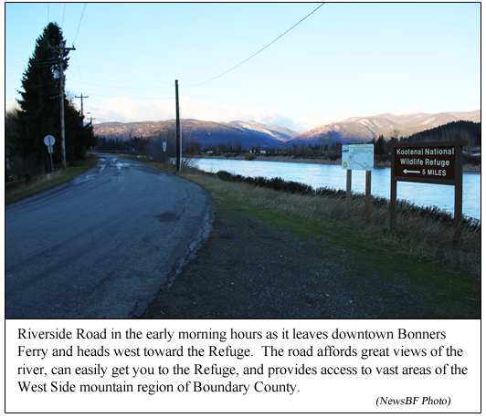
Riverside Road is the road that runs along the
Kootenai River dike past the boat launch and out
five miles to the Kootenai National Wildlife
Refuge, crossing the Deep Creek Bridge along the
way. The proposed improvements would begin at
the Bonners Ferry city limits and include the
entire road, ending at the Refuge.
(Story continues below photo)
Formal proposal submitted
The proposal, called the Riverside Road
Improvement Project Proposal, was planned, put
together, and submitted by a large and
impressive collection of agencies and groups,
both inside and outside Boundary County. The
official proposal was submitted to the Idaho
Federal Lands Access Program jointly by the U.S.
Fish and Wildlife Service, the U.S. Forest
Service, and the U.S. Bureau of Land Management,
all having lands accessed by Riverside Road, and
by Boundary County, as the entity with
maintenance responsibility for the road. Along
the way, many other groups were involved in
development and planning for the project, and
participating in committee meetings and
conferences on benefits of the plan and project
funding. These additional groups included
Friends of the Refuge, Drainage District 1, the
U.S. Army Corps of Engineers, the Boundary
Economic Development Council, the Boundary
County Historical Society, the Kootenai Tribe of
Idaho, the International Selkirk Loop, the
Kootenai Valley Resource Initiative, and local
area residents.
The proposed improvements to the road were made
under a federal program intended to fund
projects that provide better access to federal
lands. The program is administered in Idaho
under the Idaho Federal Lands Access Program,
which is aimed at providing adequate and safe
access to and through, federal lands for the
public, including visitors, recreationists, and
resource users.
Boundary County Road and Bridge prepared the 12
page application, working closely with the U.S.
Fish and Wildlife Service (which operates the
Refuge), the U.S. Forest Service, and the U.S.
Bureau of Land Management. "There was much
information and data that each Federal partner
provided for the application," said Renee
Nelson, Boundary County Road and Bridge office
manager. "We all invested much time in the
proposal from phone calls and emails to on-site
meetings. We also met with members of the
Western Federal Lands Access Program for advice
and suggestions on our proposal."
Some of the proposed improvements
The Riverside Road Improvement Project proposal
is to construct an all-season road by lowering
the levee section and relocating the earth fill
to the low areas within the project. The
proposed road width would be a 32-foot width
paved road, which would include two 12-foot
lanes with extra-wide paved shoulders to enhance
the safety of alternative modes of
transportation along the route. "Farm machinery,
logging machinery, and fire responders will
benefit from this also," said Ms. Nelson.
Riverside Road certainly qualifies as a route
that provides access to federal lands. Federal
lands for which Riverside Road provides access
include the Kootenai River via the Deep Creek
Boat Launch, The Kootenai National Wildlife
Refuge with its Interpretative Center, auto tour
route, and its handicap accesses, the
International Selkirk Loop, and numerous U.S.
Forest Service trailheads, lakes and falls.
Riverside Road provides access to over 198,000
acres of the Panhandle National Forest, over
2,100 acres of BLM lands, and approximately
2,800 acres of the Wildlife Refuge. It also
provides access to Tribal Lands of the Kootenai
Tribe of Idaho.
Proposed upgrades for the road would also
include safety improvements for all those who
use the road.
Should the final proposal be funded, the road
work would be done by Boundary County Road and
Bridge, working alongside the Western Federal
Lands Highway Division, a division of the
Federal Highway Administration. The Western
Federal Lands Highway Division would be the lead
agency for the project. The same team worked
together in the project to replace the old
Rutledge Bridge on Moyie River Road with the new
"Don Olson Memorial Bridge."
And, speaking of bridges, would there be any
changes to the Deep Creek bridge which lies on
the current Riverside Road? "There will be no
significant changes to the Deep Creek Bridge on
Riverside, as it is an existing two lane bridge
and will work well with the improvement," said
Ms. Nelson.
Submitting the proposal
The process of preparing and submitting the
proposal, and shepherding it through various
committees and approvals, was an arduous
process. The original application was submitted
just this past April by Boundary County Road and
Bridge. After all 39 applications statewide were
reviewed, Boundary County's proposal emerged
ranked in the top five, and was scheduled for a
field review by the Western Federal Lands
Highway Division (whose goal is "to improve
transportation to and within Federal and Tribal
Lands by providing technical services to the
highway/transportation community, as well as
building accessible and scenic roads that ensure
the many national treasures within our Federal
Lands can be enjoyed by all.")
 On
August 27, officials from the Western Federal
Lands Highway Division arrived in Boundary
County for an on-site review of the proposed
project. A team from Boundary County Road and
Bridge, the Kootenai National Wildlife Refuge,
and the U.S. Forest Service gave a formal
presentation at the Refuge's Educational Center,
showing the benefits of the proposed project.
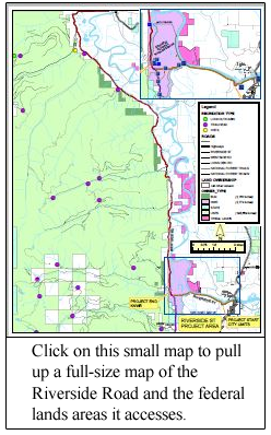
This presentation included a picture board map
of all the land accessed by Riverside Road,
which included a showcase of scenic and
prominent Boundary County landmarks, such as
Myrtle Falls, Shorty Peak Lookout, West Fork
Cabin, various mountain lakes, peaks, trails,
refuge trails, and hunting blinds, "just to name
a few," said Ms. Nelson, "to show the vast area
Riverside Road accesses." The visiting officials
were taken on a tour of the site. Boundary
County Road and Bridge had prepared signs placed
along Riverside Road showing the project points
and proposed improvements. Questions from the
Federal Lands Highway Division officials were
answered by representatives from the Refuge, the
Forest Service, Boundary County Road and Bridge,
the U.S. Army Corps of Engineers, the Kootenai
Tribe of Idaho, and the Boundary County
Commissioners. On
August 27, officials from the Western Federal
Lands Highway Division arrived in Boundary
County for an on-site review of the proposed
project. A team from Boundary County Road and
Bridge, the Kootenai National Wildlife Refuge,
and the U.S. Forest Service gave a formal
presentation at the Refuge's Educational Center,
showing the benefits of the proposed project.
This presentation included a picture board map
of all the land accessed by Riverside Road,
which included a showcase of scenic and
prominent Boundary County landmarks, such as
Myrtle Falls, Shorty Peak Lookout, West Fork
Cabin, various mountain lakes, peaks, trails,
refuge trails, and hunting blinds, "just to name
a few," said Ms. Nelson, "to show the vast area
Riverside Road accesses." The visiting officials
were taken on a tour of the site. Boundary
County Road and Bridge had prepared signs placed
along Riverside Road showing the project points
and proposed improvements. Questions from the
Federal Lands Highway Division officials were
answered by representatives from the Refuge, the
Forest Service, Boundary County Road and Bridge,
the U.S. Army Corps of Engineers, the Kootenai
Tribe of Idaho, and the Boundary County
Commissioners.
Following this field review, Boundary County's
Riverside Road Project was moved to the No. 2
priority project statewide, with one more
committee review required.
Commissioners notified of results
On November 5, about two weeks ago, Boundary
County Commissioners received notification from
the final committee that the Riverside Road
Improvement Project Proposal had been approved
for programming, with approval of $3,933,487 in
funding for the project. This funding approval
is for years 2018 and 2019. With all project
approvals and funding approvals in place, note:
approvals only, the last step would be the
appropriation of the money by Congress.
Other funding sources have been committed.
Boundary County would match funds at 7.34%. The
U.S. Fish and Wildlife Service would contribute
$250,000, and our local Friends of the Kootenai
National Wildlife Refuge committed to contribute
$1,000 to the project.
Should Congress appropriate the requested funds,
construction on major improvements for Riverside
Road would begin around 2018. |
|
|
|
Questions or comments about this
article?
Click here to e-mail! |
|
|
|
|
