|
|
|
Earthquakes and Boundary County |
|
Have we had earthquakes here before? Are
we at risk? |
|
April 27, 2015 |
A series of low-magnitude earthquakes that
occurred in the Sandpoint area last Thursday and
Friday were felt throughout North Idaho and into
areas of eastern Washington and western Montana.
Many residents of Boundary County felt the
shaking of these Sandpoint-area earthquakes.
Once the shaking had subsided, questions
regarding earthquakes in our area and region
began to surface.
Naturally, people in Boundary County wanted to
know:
• Have there ever been any earthquakes recorded
as originating in Boundary County?
• What is the risk for earthquakes in our area?
• What major earthquakes have happened in Idaho?
We hope to provide some valuable information on
these questions.
Earthquakes in Boundary County
We are talking here
not about earthquakes that may have
originated in other nearby areas whose shaking
and quaking were felt in Boundary County. We
are talking
about earthquakes whose epicenters are located
within the borders of Boundary County.
What is an epicenter? Earthquakes originate at
some point inside the earth, below the earth's
surface. The epicenter of an earthquake is the
spot on the earth's surface that lies directly
above the earthquake's actual point of origin
inside the earth. The depth of an earthquake is
how far the earthquake's point of origin is
below its epicenter.
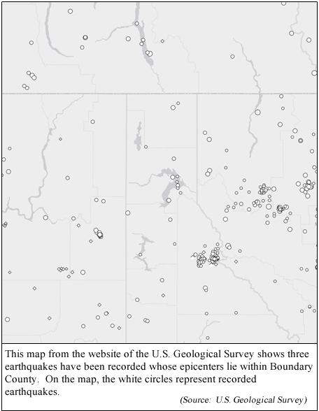
According to data on the website of the U.S.
Geologic Survey, three earthquakes have been
recorded that originated within Boundary County:
1. About 30 years ago, on November 27, 1984: At
5:07 a.m., an earthquake of magnitude 3.2 was
detected, with its epicenter located in Boundary
County, Idaho, at a point about two miles
directly west of the junction of U.S. Highway 95
with Idaho Highway 1 (the Mt. Hall
junction).This earthquake's point of origin was
about 3 miles below the earth's surface.
2. Last fall, on November 14, 2014 at 10:35
p.m., while Boundary County residents were
enjoying the last few hours of an autumn Friday
evening, a magnitude 1.8 earthquake jolted from
only 656 feet below the earth's surface. The
epicenter of this earthquake was located about
three miles east of Priest Lake, just barely
across the Boundary County line in the southern
end of the county.
3. Only 10 days later, on November 24, 2014, at
10:52 in the morning, a magnitude 1.7 earthquake
hit Boundary County with its epicenter located
about a mile and a half north of Brush Lake.
This earthquake hit at a depth about two miles
beneath the earth's surface.
(Story continues below this picture)
These are the only Boundary County earthquakes
listed on querying the Advanced National Seismic
System Comprehensive Catalog database, asking
for earthquakes recorded in our area's location
coordinates dating back to the year 1900.
Certainly other earthquakes may have occurred
during that time period before the development
or deployment of sensitive measuring devices,
but these are the only ones listed in the
database.
There have been other earthquakes with
epicenters fairly close to Boundary County,
whose shakes may have been felt within our
county, but that weren't actually located within
the county. These would include, for example,
the recent Sandpoint area earthquakes from last
week, also a couple of quakes recorded east of
Boundary County just across the state line into
Montana—a magnitude 3.1 earthquake in 1997, and
a magnitude 2.5 earthquake just this past
November.
Also, very likely several of the larger Idaho
earthquakes described below in this article were
felt by residents in Boundary County.
What is our risk of a serious earthquake
here in Boundary County?
Before a simple answer can be given to this
question, a few points about earthquake risk
measuring need to be clarified:
First, simply knowing where the nearest geologic
fault is located does not give much indication
of the risk for an earthquake in an area, since
an area can be affected by shaking from an
earthquake many miles distant.
Experts have calculated the seismic hazard for
regions throughout the United States, and have
created seismic hazard maps which show, for a
given location, the probability of different
"peak ground accelerations" that can be
generated by earthquakes. This "peak ground
acceleration" may roughly be thought of as a
measure of how hard the earth shakes in an
earthquake. It is this shaking that can cause
the damage created by earthquakes.
"Peak ground acceleration" in an earthquake is
measured as a comparison to the acceleration of
earth's gravitational force. How much "peak
ground acceleration" does an earthquake need to
have to start causing problems? Just to give an
idea, in an earthquake, people can feel shaking
at a "peak ground acceleration" of about 0.1% of
gravity. A "peak ground acceleration" equal to
2% of earth's gravitational acceleration can
cause people to lose their balance.
On this 2014 Seismic Hazard Map for Idaho, one
can see that Boundary County has two color
codes. Most of Boundary County is coded blue on
the map, while a small slice of southern
Boundary County is coded green.
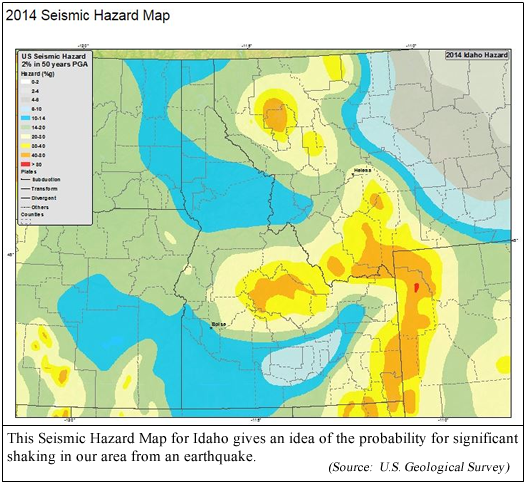
The blue-coded area of Boundary County means
that within the next 50 years, there is a 2%
chance that earthquake shaking from a "peak
ground acceleration" greater than 10%-14% of
gravity will occur.
In Boundary County's southern green slice on
this map, risk is a little higher. There is a 2%
chance that "peak ground acceleration"
earthquake shaking of 14%-20% of gravity will
occur within the next 50 years.
(Note that at a "peak ground acceleration" of
50% gravity, structurally strong buildings can
survive if the earthquake is of short duration).
All this sounds like a complicated way to
measure earthquake risk, but from a scientific
basis, that's how they do it. There isn't really
an accurate parameter that says "if you live in
Boundary County, you have an "X" percent chance
of having an earthquake." The experts say that
grading the risk is simply too complicated and
involves too many factors to be measured that
simply.
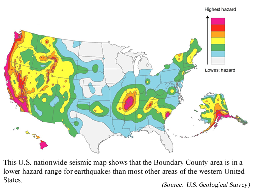
Perhaps it helps to say that in comparing
seismic hazard maps, Boundary County has a lower
risk for damaging shaking from an earthquake
than most other areas of the western United
States.
What major earthquakes have happened in
Idaho?
According to the Earthquake Information
Bulletin, a USGS publication, the first
earthquake to be recorded in Idaho's history
that caused significant damage occurred in
November of 1884, when an earthquake with
epicenter in northern Utah caused considerable
damage to houses in areas of southern Idaho.
This publication lists other significant Idaho
earthquakes, including:
An earthquake causing shaking in the Shoshone,
Idaho area in 1905, and in the Boise area in
1916. Both of these earthquakes caused
structural damages.
An earthquake shock occurred in November 1942
near Sandpoint, Idaho, felt over 25,000 square
miles.
In July 1944, a high intensity earthquake
occurred in central Idaho which caused fissures
to open in the ground, and people reported being
unable to walk due to the shaking. The shock
from this earthquake was felt over 70,000 square
miles, extending into surrounding states.
A February 1945 earthquake near Clayton, Idaho
broke dishes and cracked plaster in central
Idaho.
A December 1957 earthquake shock near Wallace,
Idaho damaged the Galena Silver Mine and
frightened miners working underground at the
mine.
A magnitude 7.1 earthquake in 1959 in Montana
caused millions of dollars in damage, and killed
28 people. Idaho experienced damage from this
earthquake in the Big Springs, Henry's Lake, and
Island Park areas.
A 1962 earthquake in northern Utah caused large
landslides in the Fairview, Idaho area. Building
damages occurred in the southern Idaho towns of
Franklin and Preston. Shaking from this quake
was felt over a 65,000 square mile area in five
states.
An April 1969 shock of magnitude 4.9 caused some
damage in the Ketchum area.
Idaho's largest earthquake
According to Seismicity of the United
States, 1568-1989, a USGS publication
authored by Stover and Coffman, the largest
known earthquake in Idaho happened near Mt.
Borah, Idaho's highest peak, in October 1983.
The earthquake's 6.9 magnitude is the highest
ever recorded in Idaho. This earthquake resulted
in two deaths in the Challis area, and an
estimated $12.5 million in damage in the
Challis-Mackay area, where hundreds of buildings
were damaged, including many severely damaged
structures. The Challis High School had
extensive damage. The earthquake caused
significant ground breakage, rockfalls, and
landslides.
Shaking from this earthquake was felt over
several states and up into Canada. Aftershocks
continued through the remainder of 1983.
|
|
|
|
Questions or comments about this
article?
Click here to e-mail! |
|
|
|
|
