|
Getting ready for the (possible) snow storm |
|
12:20 a.m. Tuesday, December 19, 2017 |
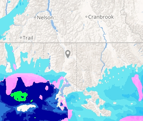 |
As of 12:05 a.m., there are no adverse road
reports in Boundary County and the radar capture
above shows most precipitation falling as rain, heavy
at times (dark blue/green), rain/snow mix (pink)
and snow (light blue) to the south of us, with
the system at present moving east northeast into
south Bonner County.
In areas around Priest Lake, up to a foot of new
snow is expected in the valley through tomorrow
afternoon.
There was heavy rain today in western Montana,
which has turned to snow in south Lincoln County
below Libby, and the 11:55 p.m. temperature in
Libby is 28 degrees, so road conditions there
are likely extremely slick, with heavy snowfall
of 10 to 15 inches are expected this morning
through Wednesday on Highway 2 from Libby to
Kalispell, Highway 37 from Libby to Eureka, and
along Bull Lake Road.
Be alert to areas of dense fog, and be aware
that there are potentially areas of patchy black
ice on roadways throughout the region.
Snow is expected mainly after 1 a.m. with an
overnight low in Bonners Ferry of around 32.
Chance of precipitation through Tuesday morning
is 80%, with total snow accumulation of two to
four inches possible in the valleys by the time
of the morning commute.
Snow could be heavy at times through the day
Tuesday, with high temperatures near 36 and a
north wind around seven miles per hour, which
could produce lightly blowing snow which could
reduce driving visibility. The chance of
precipitation throughout the region is near
100%. New snow accumulation of five to nine
inches in the valleys are possible by Tuesday
night.
Travel will be very difficult on Tuesday. From
tonight through Tuesday afternoon, valley
accumulations of five to nine inches are
forecast for Bonners Ferry, Naples, Sandpoint
and Clark Fork.
But ...
According to the National Weather Service,
temperatures hovering around the freezing point
at the lower elevations make this a difficult
forecast. Precipitation in valley communities
may periodically be a mix of rain and snow,
limiting lowland accumulations. For the
mountains, this storm will produce as much as
two feet of new snow tonight through Wednesday
morning.
Temperatures in the low to mid 30s may limit
lowland accumulations for areas south of
Sandpoint.
Snow could result in trees collapsing. This
could cause intermittent and sudden road
closures as well as power outages. As of 11:45
p.m., there are no power outages showing in the
Northern Lights service area. If outages occur
and you are a Northern Lights member, call
1-866-665-4837 to report an outage. If power
should go out in areas served by the City of
Bonners Ferry outside of normal office hours,
call the sheriff's office at (208) 267-3151,
extension 0.
If possible stay off the roads, but if you must
travel, keep an extra flashlight and good
batteries, blankets and warm winter clothing,
including boots, hats and gloves, food and water
in your vehicle in case of an emergency. The
latest road conditions for the state you are
calling from can be obtained by calling 511. |
|
Questions or comments about this
article?
Click here to e-mail! |
|
|
|
|
