|
Expect yucky, slick roads Thursday morning |
|
November 15, 2017 |
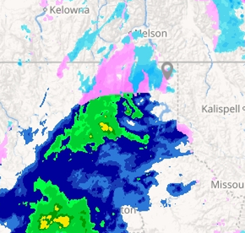 |
| Radar
picture captured at 8:20 p.m. |
By Mike Weland
Get ready for a mixed bag of weather, as a
system brings rain, freezing rain and mountain
snow to Boundary and Bonner Counties in Idaho
and Pend Oreille County, Washington, and rain,
yuck and slop to points south tonight. Heavy
mountain snow is expected, with four to eight
inches possible above 4,000 feet.
The snow level is expected to drop to 3,000 feet
by morning, turning most of the precipitation to
snow; one to three inches are possible in valley
locations. The snow is expected to turn back to
rain Thursday afternoon, with temperatures
warming into the low 40s, but will turn back
over to snow as temperatures drop into Thursday
night, with an addition inch of valley snow
predicted.
Tonight's chance of precip is pegged at a
certainty, 100-percent, while it drops to
70-percent on Thursday.
Tonight's moisture is likely to make morning
road conditions an absolute mess, so be sure to
leave a little earlier than usual for the
morning commute and take it slow and easy going
in.
Cloudy conditions and frozen mix is expected to
continue all week to next Thursday, with daytime
highs in the upper 30s to low 40s and overnight
lows in the low to mid 30s. |
|
Questions or comments about this
article?
Click here to e-mail! |
|
|
|
|
