|
Clear skies in west predicted for eclipse |
|
July 18, 2017 |
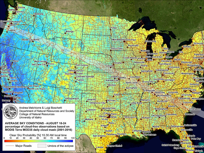 |
Researchers from the University of Idaho’s
College of Natural Resources (CNR) have
developed a map that shows the likelihood of
clear viewing of the solar eclipse coming
August 21.
This map documents the probability of clear sky
based upon location and was developed using 16
years of daily satellite observations from the
MODIS sensor onboard the Terra Satellite, which
is operated by NASA.
Luigi Boschetti is an associate professor of
remote sensing in the department of Natural
Resources and Society and Andrea Melchiorre is a
doctoral student in CNR who is funded by a NASA
Earth System Science Fellowship to assess the
impact of clouds on global fire mapping
capabilities from satellite.
The two adapted methods and the programming code
that was developed for Melchiorre’s doctoral
dissertation to generate the clear sky
probability map.
“There have been many maps created to document
the path of the eclipse through the United
States and the world,” Boschetti said. “This map
is unique because we have added information on
the probability of clear skies — meaning how
well you will actually be able to see the
eclipse from where you are located in the U.S.”
The map shows that viewing conditions in the
western U.S. will generally be very good, but
will decline as the eclipse path heads east.
The map composition was built using publicly
available data sources. More information
regarding the data sources, a high resolution
version of the above map and Google Earth
interactive map versions are available at
www.uidaho.edu/solareclipse. |
|
Questions or comments about this
article?
Click here to e-mail! |
|
|
|
|
