|
|
Severe thunderstorm watch in effect
|
|
July 20, 2012 |
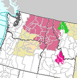 |
|
Areas shaded
light mauve indicate the scope of the
severe thunderstorm watch issued this
morning be the National Weather Service. |
At 11:34 a.m. today, the National Weather
Service, Norman, Oklahoma, issued a severe
thunderstorm watch for a large portion of the
Pacific Northwest, including Boundary County,
Idaho, through 8 p.m. this evening.
The watch area is defined as being along a
130-mile line running east and west from
approximately 90 miles east northeast of Omak,
Washington to 50 miles south of Lewiston, Idaho.
According to the National Weather Service,
conditions in this area are favorable for wind
gusts up to 70 miles per hour, hail as much as
two inches in diameter nand dangerous lightning.
While rare in this region, they advise that this
system could spawn tornadic activity.
As of noon, scattered thunderstorms were
intensifying across parts of northern Oregon and
central Washington ahead of an approaching
mid-level shortwave trough. Strong heating into
the afternoon will result in steepening
low-level lapse rates and a moderately unstable
air mass.
Aviators are advised that these storms will
carry extreme turbulence and vertical shear,
wind gusts of up to 60 miles per hour and
damaging hail aloft. A few cumulonimbi with
maximum tops to 450 and a mean storm motion
vector of 22030. |
|
|
|
|