|
|
Risk of flooding still high
|
|
April 21, 2012 |
|
|
With the record moisture that fell throughout
the region in March, much of it snow at the
higher elevations, and prolonged cool
temperatures, local emergency managers are
concerned that a warm up could bring significant
local flooding.
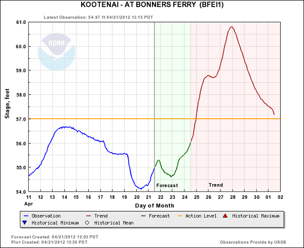
The Northwest River Forecast Center, part of the
National Oceanic and Atmospheric Administration
(NOAA), predicts that the elevation on the
Kootenai River at Bonners Ferry could reach very
close to 61 feet by early next weekend.
Flood stage is 57 feet.
According to county emergency incident commander
Bob Graham, March precipitation in the Panhandle
mountains was a whopping 225-percent of normal
average. He said the Schweitzer basin received
18 inches of precipitation last month, nearly a
foot more than the previous March snowfall
record.
According to Graham, several area creeks are
also running high this spring, particularly
Smith Creek, which is running at 129-percent of
its spring average.
At the beginning of this weekend, inflow into
the Koocanusa Reservoir in Libby was 9,000 cubic
feet per second (kcfs) and outflow at Libby Dam
was 18 kcfs. Outflow has been slowed to 16 kfcs
and is expected to remain at that level through
Sunday.
"The rapid snowbuilding that we saw in March has
slowed significantly since the beginning of
April," wrote Army Corps of Engineers hydraulic
engineer Kevin Shaffer. "The April-August inflow
forecast is 6,872,000 acre feet (KAF), which is
117-percent of the 1975-2009 average. This
corresponds to 3,058 KAF of required flood
space, or elevation 2377.3 feet. We will be
operating Libby Dam to draft the reservoir to
the higher of 1) 2377.3 feet and 2) the computed
95th percentile refill curve. The current
estimate for the refill curve elevation is
approximately 2,382 feet.
The current level of the Koocanusa Reservioir is
2,382.6 feet.
Temperatures as we head into the week are
expected to warm, with Sunday dawning mostly
sunny before clouding up late in the day with
high temperatures reaching the upper 70s. Sunday
night brings a slight chance of rain showers and
low temperatures in the mid 40s, and
temperatures could reach the 80s on Monday.
Monday night through Wednesday promises to be
mostly cloudy with a 50-percent chance of
showers and thunder showers, with temperatures
in the upper 60s to low 70s.
Rain is likely Thursday and Thursday night, with
overnight lows dropping back into the 30s, and
then a period of cooler temperatures are
expected with continued chance of precipitation
Friday and into next weekend.
The spike in temperatures expected through this
week has Graham concernced that problem flooding
could occur, and he's encouraging everyone in
areas prone to flooding to keep an eye out for
flooding problems and take steps to mitigate
potential flood damage.
Sandbags and sand are available for free to
county residents at the county landfill and at
the front fence at County Road and Bridge. Those
experiencing flooding problems should report
them at the earliest possible time by calling
the Boundary County Sheriff's Office, (208)
267-3151, extension 0. |
|
|
|
|