 |
|
August 17, 2023 |
If you live here, you
already know this:
Boundary County and
its surrounding regions have had increasing
smoke in our skies, much more dense over the
past few days. And it seems to be getting worse.
We hope to provide
some insight into why our skies have become so
smoky, and hopefully amswer some questions you
might have.
Note that all of the
following maps and images presented in this
article are current as of today.
SATELLITE
IMAGE OF OUR SKIES
The image below is
compiled by NASA and the Fire Information for
Resource Management System. This image is from
today, August 17, 2023.
This image is a near
real-time image put together from satellite
photgraphic information, fire data,
spectroradiometry, infrared imaging radiometry.
One can see the smoke
in the general region around the North Idaho
panhandle, also smoke seen east and south of
Idaho.
|
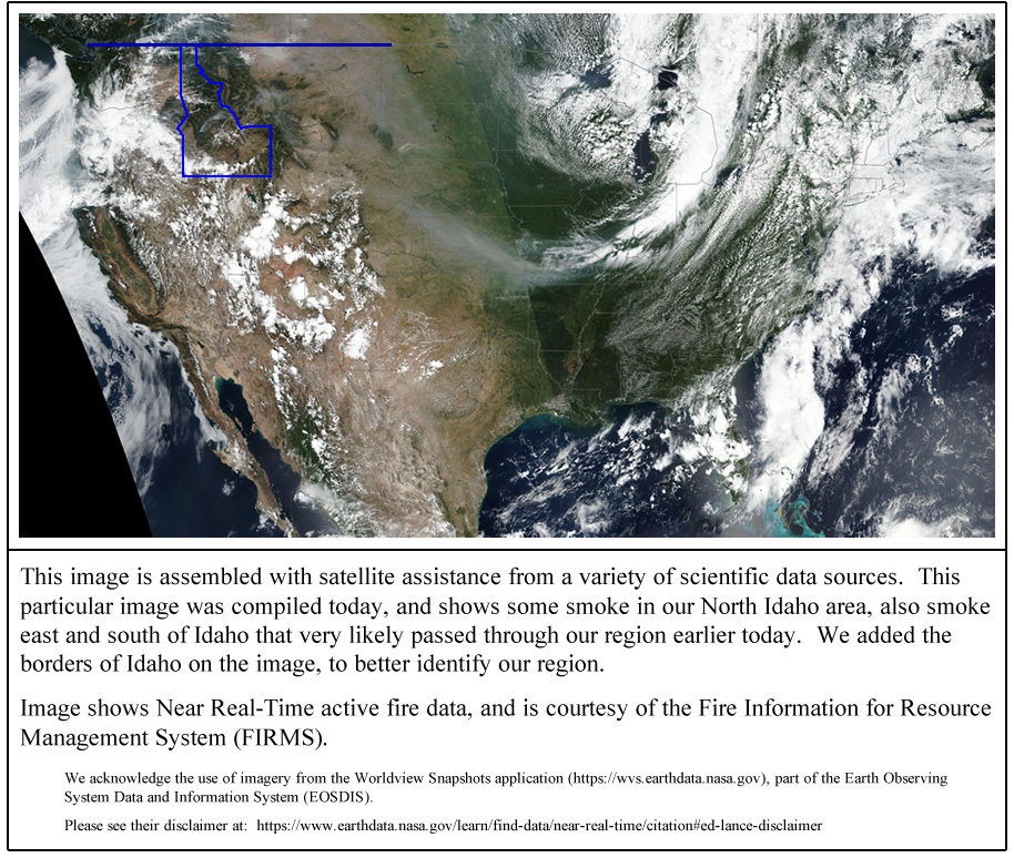
Given that the Jet
Stream always runs from west to east, it seems
we can presume the smoke to the east and south
of Idaho already drifted through our area, and
the smoke seen to be north and west of the Idaho
Panhandle was likely moving into our area, at
that time.
The image above is a
satellite image, looking at the United States
from above. It visualizes what we are seeing,
breathing, and living in here on earth in
Boundary County and North Idaho (and the Creston
Valley, acros the Canadian border).
WILDFIRES
ACROSS THE COUNTRY
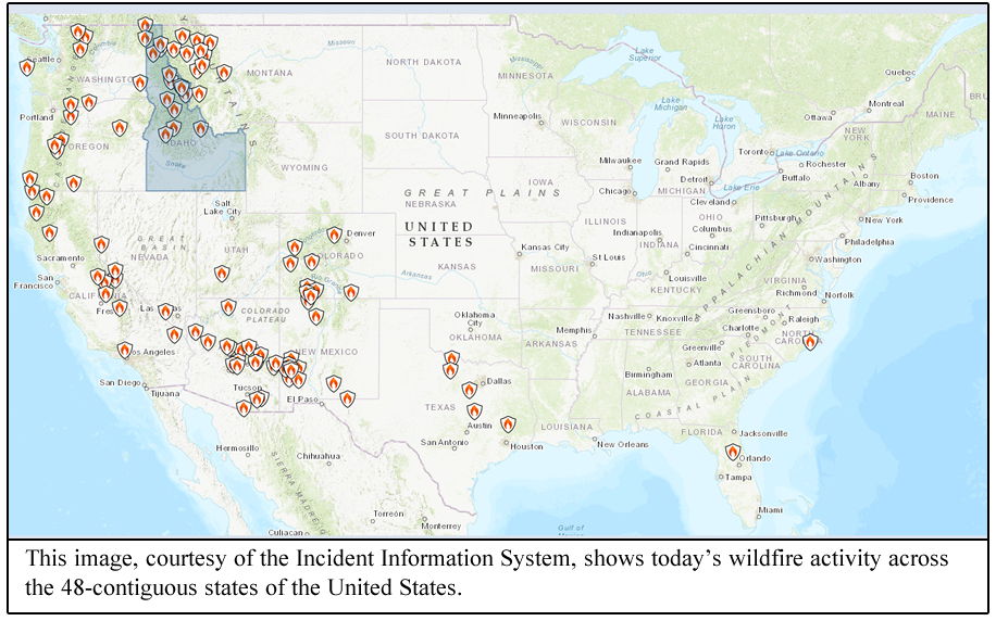
Wildland fires are a
major reason for our smoke. The next image,
below, is a map showing current wildfire
incidents across the lower 48 contiguous states
of the United States. As one can see, many of
those fires are concentrated in the Pacific
Northwest area.
The following image
is a zoomed-in view of the map just shown above.
This close-up image shows our nearby, regional
fires in a more individual way.
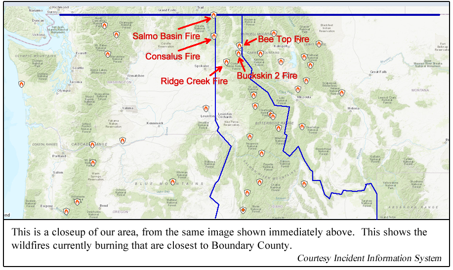
Here is some of the
basic information on the five wildfires
currently burning near us in the Idaho
Panhandle, as shown on the above map:
1. The Salmo Basin
Fire is located in the extreme northeast corner
of Washington, just on the Washington side of
the Washington / Idaho border. This fire
originated on July 30. It is a Lightning /
Natural-caused fire. As of today, it has burned
70 acres. Fifteen personnel are assigned to this
fire. It is zero percent contained.
2. The Consalus Fire
is located in Washington, just a little inside
Washington across the Washington / Idaho border.
This fire is about 10 miles west of Priest Lake.
This fire began June 30, and is lightning
caused. It has burned 475 acres. The fire has 43
personnel assigned to it. It is currently 80%
contained.
3. The Bee Top Fire
is located about 5 miles northeast of Clark
Fork, Idaho. This fire's date of origin is July
1. It has burned 45 acres, and is 95% contained.
4. The Buckskin 2
Fire is 8 miles south of Clark Fork, Idaho. This
fire started August 4. Its cause is undetermined
so far. It has burned 242 acres, and has 170
personnel assigned.
5. The Ridge Creek
Fire is near Hayden Lake, Idaho. It originated
August 3. This has been determined to be a
human-caused fire, and is being investigated.
This fire has burned 3,248 acres, and is
currently 12% contained.
WILDFIRES IN
NEARBY CANADA
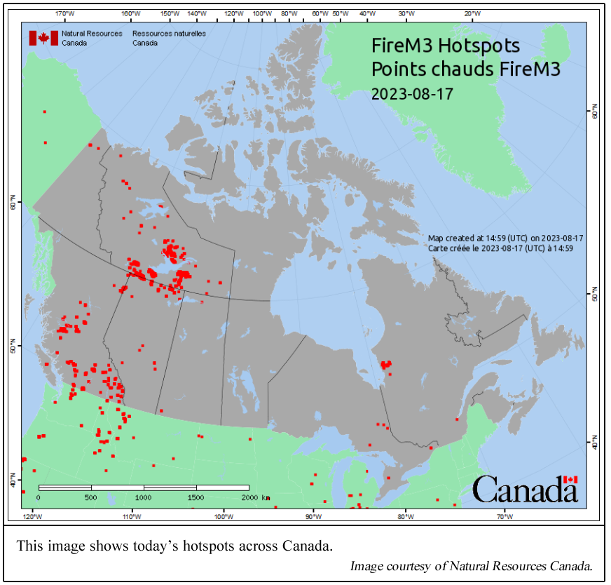
There are also many
fires north of us, inside Canada. These are
illustrated in the following image, which shows
hotspots across Canada.
IMPACTS ON
OUR AIR QUALITY
How has this impacted
our air quality? Answer: Obviously, yes,
and in a bad way.
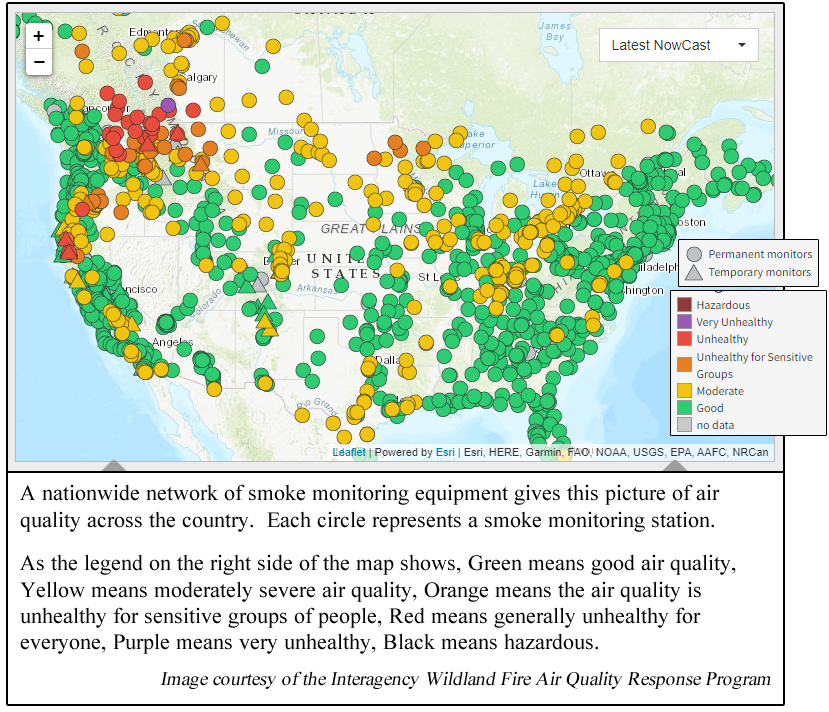
The following image
shows a network of smoke monitoring equipment
positioned at points across the United States.
These smoke monitors measure fine particulate
matter, PM2.5. Each dot in this image represents
a monitoring station. One can see the heavy
concentration of those smoke monitoring stations
in our area reporting air quality in the range
of Moderately Severe (yellow circles), to
Unhealthy for Sensitive Groups (orange circles),
to Unhealthy, period (red circles).
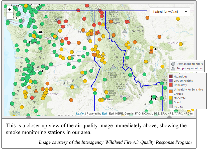
The next image shows
a zoomed-in look at the smoke monitoring
stations in the Pacific Northwest area,
including close-in views of North Idaho.
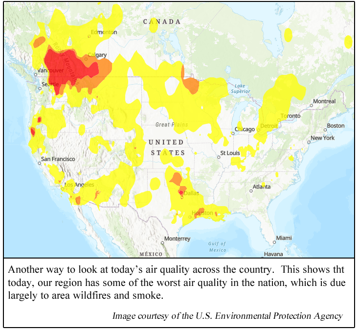
And finally, in our
last image, sort of the same information, just
with a different look. This is a map from the
U.S. Environmental Protection Agency, which
shows once again the unhealthy air quality in
our area. This image shows that our usually
beautiful area, today sadly happens to have some
of the worst air quality in the nation.
OTHER IDAHO
WILDFIRES
Above, we mentioned
the five wildfires currently burning most
closely to Boundary County. Just to be complete,
there are a total of 14 wildfires burning in
Idaho today. Herer are the largest two of those
wildfires:
1. The Elkhorn Fire
is the largest Idaho wildfire today, currently
burning in central Idaho in the Bitterroot
Range. This fire has burned 26,048 acres. It
started July 24. Its cause is as yet
undetermined, and is under investigation. This
fire has 225 personnel assigned, and is
currently 45% contained.
2. Idaho's current
second-largest wildfire is the Hayden Fire—not
to be confused with the Ridge Creek Fire located
at the Hayden Lake area. The Hayden Fire is
burning in the Lemhi Mountain Range, within the
Salmon-Challis National Forest. This fire
started July 19. It has burned 24,706 acres, and
is being battled by 20 firefighter personnel.
|
|
|
|
|

