 |
|
February 10, 2022 |
How are the mountain
snowpacks shaping up so far this year? Does it
look like we will have adequate snowpack and
water supply as 2022 unfolds?
The experts who
measure and study these things look at what they
call the "Water Year." The Water Year does not
follow a regular calendar year. The Water Year
begins on October 1 of a given year, and runs
until September 30 of the following year. So
right now, we are in February of the Water Year
that began October 1, 2021 and runs until
September 30, 2022. That makes us about 4 1/2
months into the current Water Year.
The U.S. Department
of Agriculture has divisions that monitor and
measure snow and rain for areas around the
nation. Stations are maintained that measure
snowfall and also measure what is called "snow
water equivalent," which is how many inches of
water there would be if the snow at that station
were to melt completely.
Two of these
measurement stations are located in Boundary
County. One is located near Hidden Lake, in the
northwestern part of Boundary County high in the
Selkirk mountains, at an elevation of 5040 feet.
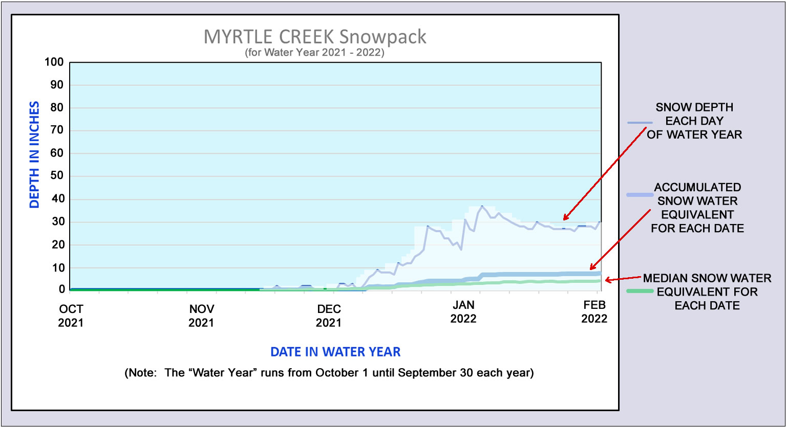
The other measurement station is in the Myrtle
Creek area, at a lower elevation of 3520 feet.
These two measurement
stations monitor snowfall and precipitation in
our area. And what they are showing us so far in
this Water Year looks good.
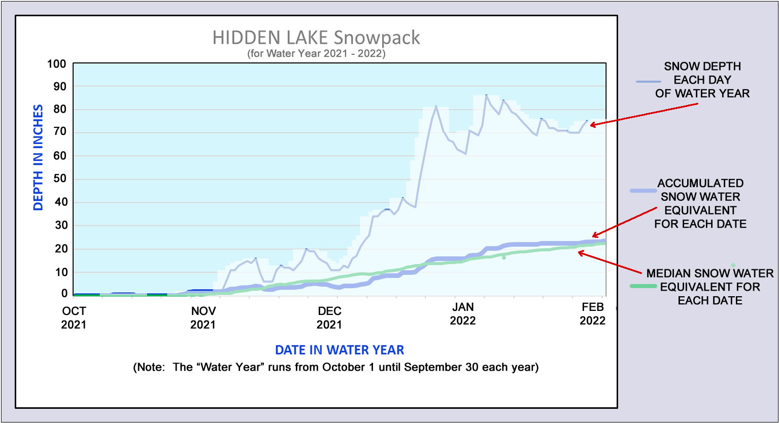
At the Hidden Lake
station, as of today, February 10, the snow
level is at 73 inches. The water equivalent of
that snow, if it were to all melt, would be 23.6
inches of water. Looking back over the past 30
years, the water equivalent of the snow at the
Hidden lake station today is 104% of what would
be considered normal over our past 30 years.
At the lower
elevation Myrtle Creek station, as of today, the
snow level is at 28 inches. The water equivalent
of that snow would be 7.6 inches of water.
Looking at the past 30 years, the water
equivalent of the snow at the Myrtle Creek
station today is 173% of what has been typical
over our past 30 years.
The following two
graphs give a picture of those numbers, showing
snow depth at those two stations, what the water
equivalent of that snow is, and what the median
water equivalent is over the past 30 years.
(Story continues
below these graphs).
Here is the snowpack graph for Hidden
Lake.
To see a larger version of this graph,
click on the graph.
Here is the snowpack graph for Myrtle
Creek.
To see a larger version of this graph,
click on the graph.
These numbers are
telling us that the water equivalent of the
current snow at both of our Boundary County
measurement stations is above normal for the
Water Year, with Hidden Lake 4% higher than
normal over the past 30 years, and Myrtle Creek
73% higher.
So far, it appears we
have a good snowpack to provide for our water
needs for the coming spring, summer, and fall
months. Area weather forecasters are saying we
will continue to have a few more warm February
days, with the possibility of more mountain
snows on Monday.
|
|
|
|
|
|
|